1-Visualise the trace with RaceChrono for windows in full screen, adjust the zoom 500m. You obtain a half picture on a standard monitor 1280x1024, press "ALT-PrintScreen". Paste it in your favourite image processing. The best is software that supports layers and transparency. Using the selection function by color and remove all the black. In RaceChrono move the trace so as to have the missing portion and proceed the same way as the first half image. Paste it in your image processing and made 2 pieces of matching images. Then add a 1-pixel border black color to the trace, it makes it more visible. When it's over, about the trace : in larger dimension measure the size in pixels from one side to the other.
2-Download the satellite image, for example with
NoniMapView
chose a sufficient Zoom (approx 18 on NoniMapView). The pixel size of the uploaded image must be greater than the pixel size of RaceChrono trace. Open it with your image processing software, resize it in order to regain the previous measurement of the trace. Paste the RaceChrono trace on another layer.
The satellite image is not always the right size? resize it ...
At the end we have to adjust your trace (remember your trajectory on the track) to find the ideal size of the satellite image.
The resizing of the satellite image applied can vary from lap to another ... but the final result is interesting.
En français
1-Visualisez le parcours avec RaceChrono pour Windows en mode plein écran, réglez le zoom à 500m. Vous obtenez une image partielle sur un moniteur standard 1280x1024, pressez sur "ALT-ImpEcran". Collez la dans votre logiciel de retouche d'image favori avec si possible le support des couches et de la transparence. Utilisez ensuite la fonction sélection par couleur et supprimez tout le noir. Avec Racechrono déplacez la trace dans la portion qui vous manque et procédez de la même manière que pour la première demi image. Assemblez correctement les 2 demi-images. Ensuite rajoutez une bordure noire de 1 pixel autour de la trace pour qu'elle soit plus visible. Quand c'est fait, mesurer dans la plus grande longueur la taille en pixel d'un bord à l'autre de la trace (sens Nord Sud pour la piste d'Alès par exemple).
2-Télécharger l'image satellite, par exemple avec
NoniMapView
choisissez un zoom suffisant (approximativement 18 sur NoniMapView). La taille en pixel de l'image doit être supérieure à la taille en pixel de la trace de RaceChrono.
Ouvrez cette image avec votre soft de retouche et redimensionnez là de façon à retrouver la taille de la trace que vous avez mesuré précédemment. Coller la trace RC sur une autre couche. A la fin il vous faudra ajuster la trace (rappelez vous de votre trajectoire sur la piste) pour trouver la taille idéale d'image satellite.
Le redimensionnement de l'image satellite à appliquer peut varier d'un tour à l'autre ... mais le résultat final est intéressant.
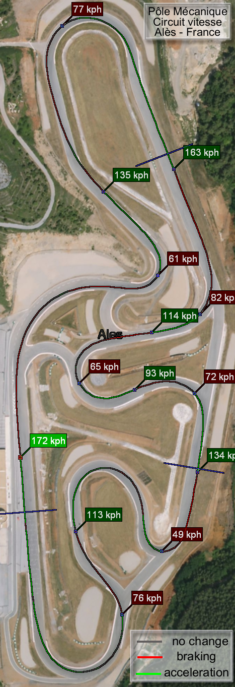
The result for "Ales/France" Track :
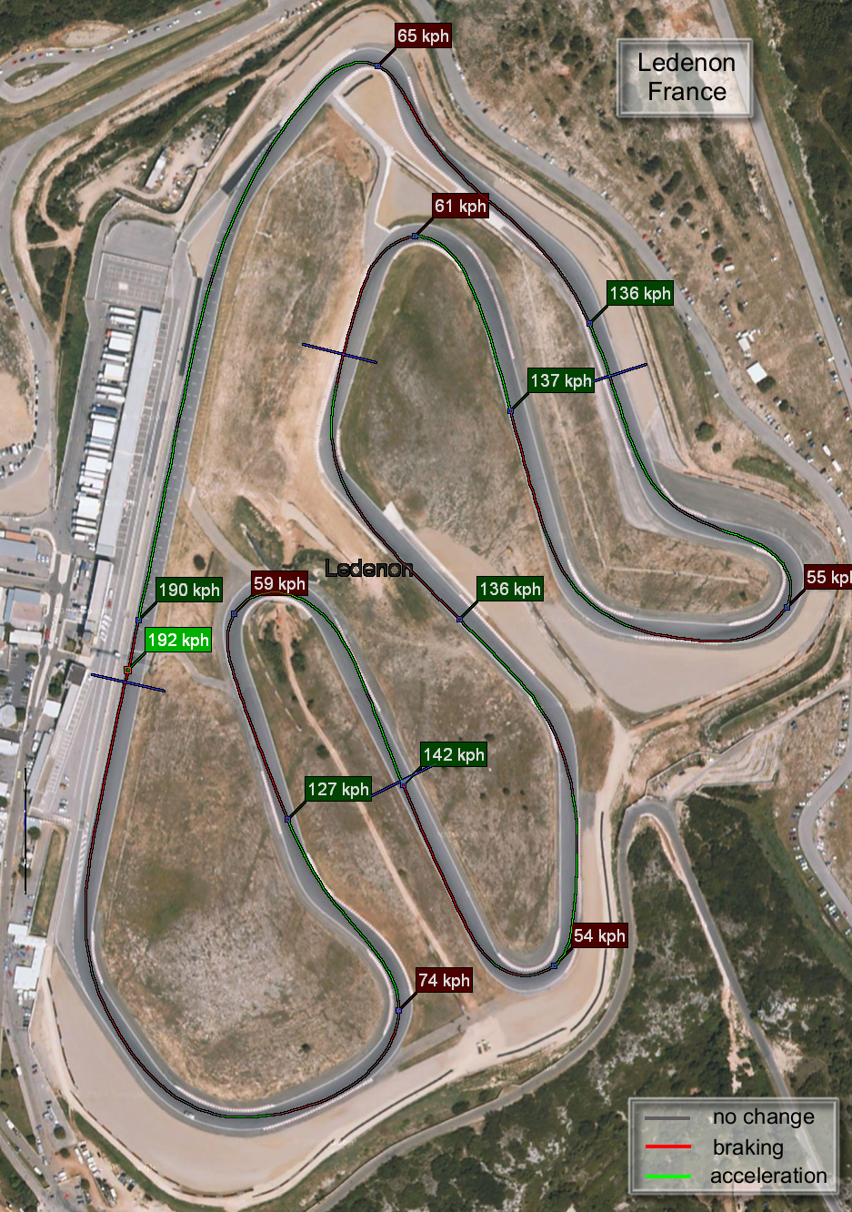
and for "Ledenon/France" Track :
And once again we can appreciate the excellent work of the author of RaceChrono.

Comments
We can analyze the progression over time of the driving experience.
We can also compare the power differences of motorbikes.
You can view it here.
There is an index to the left to quickly jump from one view to another with the keyboard.
this thread should be stick'ed, it's hard to find on the third page!